A public beach camera may look like a simple window onto the shoreline. For Bethune-Cookman University researchers, it can also become a stream of scientific data — one image at a time.
At the American Geophysical Union's 2025 Annual Meeting in New Orleans, B-CU-linked research teams presented two projects that use high-resolution beach-camera images and machine learning to better understand coastal inundation and shoreline change. The work placed student researchers Samantha Velasco and Kisha Mulenga at the front of a collaboration spanning environmental science, computer science, engineering and coastal management.
The first project, led by Velasco, examined how surveillance-camera images can track coastal inundation and wave dynamics at public beaches. The second, led by Mulenga, focused on real-time shoreline monitoring through deep-learning-based semantic segmentation — a computer-vision method that teaches a model to classify different parts of an image.
Both projects appeared in the official program for AGU25, held Dec. 15-19 at the New Orleans Ernest N. Morial Convention Center. The annual meeting is the world's largest gathering in Earth and space science, bringing together more than 20,000 scientists, students, educators and communicators.
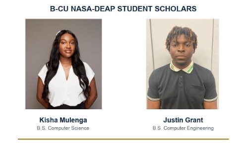
B-CU student scholars Kisha Mulenga, computer science, and Justin Grant, computer engineering, are featured in the institute's official NASA poster. Source: NASA Technical Reports Server archival poster; confirm reuse and final credit.
Turning a live camera into a research instrument
The research centers on South Dunlawton Beach in Volusia County, where a publicly accessible camera provides time-lapse views of the beach. Instead of treating those images as snapshots, the team processes them with artificial neural networks trained to distinguish water, wet sand and dry sand.
That distinction matters because the movement of water beyond the normal shoreline can affect dunes, wildlife habitat, recreation and nearby infrastructure. Repeated images also give researchers a way to observe changes at a finer time scale than many traditional surveys can provide.
In practical terms, the model learns to color-code the beach scene by surface type. As conditions change, the classified images can help the team measure where water reaches, how the visible shoreline shifts and how wave run-up changes the beach face.
The approach does not replace field measurements or satellite observations. It adds another layer: a relatively low-cost, frequently updated view that can be compared with other coastal data and improved as the model sees more conditions.
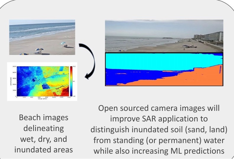
Beach-camera imagery is converted into classified zones that help researchers distinguish water, wet sand, dry sand and inundated areas. Source: NASA Technical Reports Server archival poster; confirm reuse and final credit.
A student pipeline built around real problems
Velasco and Mulenga's projects were developed with a broader team that includes B-CU student scholar Justin Grant and research collaborators Juan Calderon, Keenan Hubbard, Stephen C. Medeiros, Kelly San Antonio and Hyun J. Cho. Their shared work reflects the interdisciplinary design of B-CU's NASA MUREP-DEAP Institute of Environmental Intelligence for Advanced Space-based Earth Sciences.
Bethune-Cookman leads the three-university institute with Alabama A&M University and Embry-Riddle Aeronautical University. Supported by a $1.5 million NASA award, the consortium gives students research experience, data-science training, conference travel and pathways to internships at NASA centers.
The institute's larger research goal is to strengthen how scientists observe changing water levels across multiple time scales — from individual storms to long-term sea-level rise. Machine learning, satellite information, field data and public-camera imagery become parts of the same effort to help coastal communities better understand risk.
For B-CU students, presenting at AGU25 meant more than displaying a poster. It placed their methods and questions inside a global scientific conversation, gave them experience explaining complex work to specialists and showed how classroom skills can be applied to an urgent challenge close to home.
The clearest story is visible in the images themselves: a beach, divided into measurable zones, becoming a laboratory. Through that lens, B-CU students are not only learning how environmental data are analyzed. They are helping build the tools that may shape how communities watch a changing coast.